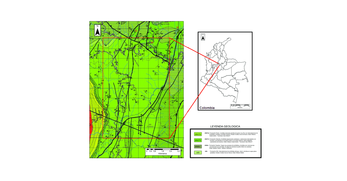
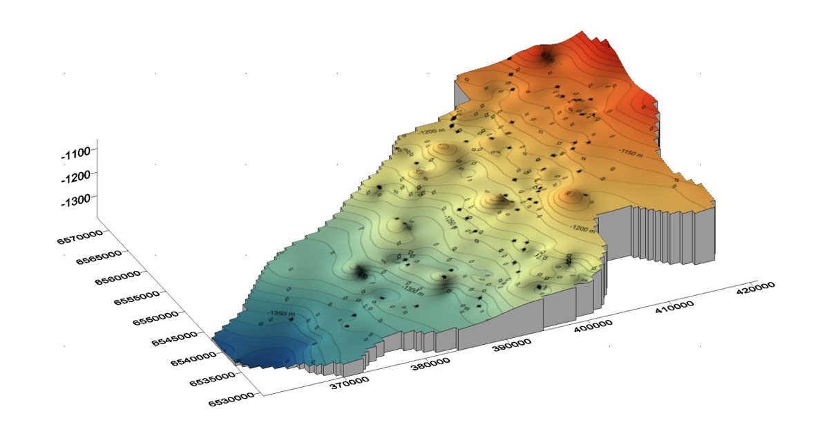
Evaluating Offshore Petroleum Exploration Opportunities

Each year, the governments of Australia and New Zealand conduct an acreage release program in an effort to promote responsible offshore petroleum exploration within their respective countries (1). Areas are first nominated for release by the industry. Thereafter, the governments assess the areas while taking into consideration maritime boundaries, environment, fisheries, defence, maritime safety, communications, and native title interests (2). Finally, the selected areas are offered to the petroleum industry where individual companies bid on the released blocks under competitive work program tender.


Overview map of the Australian 2017 release areas
Overview map of the Australian 2017 release areas.


Batole Pty. Ltd., a privately owned oil and gas consultation and investment company, analyzes the acreage offerings for exploration opportunities. Although Batole has up to six months to conduct acreage analysis, the available areas are both large and numerous and require an intensive evaluation effort. Efficient, flexible, and accurate tools are key when conducting the assessment. Batole has found Golden Software’s 2D and 3D mapping, modelling, and analysis software programs, Surfer, Strater, Didger, and Voxler, are ideally suited for this task.


Information provided with the release areas include comprehensive geological and geophysical datasets. In addition to the regional geology, tectonic development, and exploration history, 3D seismic surveys and wireline log data are typically provided to enable the completion of a comprehensive technical evaluation.


The 3D seismic surveys provides Batole structural control for the blocks under consideration. Batole first conducts seismic interpretation using IHS Kingdom®. Thereafter, horizon files are imported into Surfer for gridding and contouring.


“Surfer works very well with these large grid files,” commented Robert LaRue, Managing Director of Batole. “It easily handles these datasets even when grid cell spacing is reduced to the bin size of the 3D seismic data. Surfer’s ability to quickly grid and display seismic data in a variety of different formats enables real-time feedback when conducting the seismic interpretation.”


Surfer 2D & 3D mapping, modeling & analysis software: Relief map reveals information on fault orientation for fault interpretation of seismic data
The Surfer relief map reveals information on fault orientation which
assists with fault interpretation of seismic data.


Another important aspect of Surfer is the ability to perform mathematical functions on the underlying grid files. For example, when conducting hydrocarbon volume estimation, important variables such as gross pay, porosity and water saturation are mapped separately. To produce a hydrocarbon pore volume map, the underlying grids files for each individual map are simply multiplied. Mathematical operations are also used on grid files to perform seismic time-to-depth conversion and isochron and isopach mapping.


Surfer 2D & 3D mapping, modeling, and analysis software: Contour maps are used to display depth structure maps and gross oil pay maps
A variety of information such as depth structure and gross oil pay maps are
displayed with Surfer’s contour map option.


For the log data analysis, Batole turns to Strater. “Strater is an invaluable tool when displaying and manipulating this wireline log data,” said LaRue. Strater provides a ready platform from which interval data such as lithology, sidewall cores, conventional core analyses, composite logs and other items such as palynology can be plotted.


Strater, geotechnical and geoenvironmental mapping, modeling, and analysis software
Log data in LAS or Excel formats is quickly imported into Strater for the construction of
composite logs. Lithology, rock physics, and reservoir attributes are easily visualized in Strater.


Where LAS digital formats are unavailable, Batole relies on the use of Didger to capture key wireline log data. PDF is the typical format used when providing Well Completion Report data. These PDF composite logs are easily imported into Didger for quick and accurate digitization. Once the desired log curves are captured, LAS files are exported and imported into Strater for display.


Surfer - isopach map and full-stack amplitude underlay, Strater composit log
By using the different Golden Software tools, Batole can quickly visualize and analyse the
numerous datasets provided with the acreage release.


Finally, for a complete three-dimensional picture, Batole turns to Voxler for complex visualization purposes. Voxler combines the structure from Surfer and stratigraphy from Strater to create a 3D rendition of the area of interest.


Voxler | 3D geologic and scientific modeling software
Voxler delivers a complete, three-dimensional picture of the area of interest.


“The software suite provided by Golden Software provides an effective toolset for petroleum exploration and development activities where speed, flexibility and accuracy are required,” concluded LaRue. “I don’t have to sacrifice quality for efficiency with these products.”


A privately owned Australian company, Batole Pty. Ltd. has been active since 1999. Batole provides both consultation services and investment opportunities to the oil and gas industry.


Robert LaRue is a Petroleum Geoscientist with over 47 years of international industry experience. He is credited with multiple oil discoveries in Kansas, USA, East Kalimantan, Australia, Papua New Guinea, and offshore China. Mr. LaRue is the Managing Director of Batole Pty Ltd. and has held this position since 1999.


Sources

  1. http://www.petroleum-acreage.gov.au/
  2. http://www.ga.gov.au/scientific-topics/energy/resources/petroleum-resources/offshore-acreage-release


Exceeding expectations

Our customers

Go to top