How Professor Mine Dogan Is Preparing Future Scientists at WMU’s Hydrogeology Field Camp
Every summer, Western Michigan University (WMU) hosts a Hydrogeology Field Camp, an immersive, hands-on experience designed to equip the next generation of scientists with the tools they’ll need to succeed in the field. The camp lets students tackle data collection, interpretation, and visualization—all while working under the guidance of leading experts in geoscience.
Last year, we gave a glimpse into the structure of WMU’s Hydrogeology Field Camp with an overview of the different modules students complete. This year, we’re diving deeper, starting with the very first module of the course and the professor who leads it: Mine Dogan. A geophysicist with years of experience in both teaching and fieldwork, Mine runs the Surface Geophysics module. Her goal for the course? To teach students how to see beneath the surface with innovative methods and software.
Understanding Geophysics in an Environmental Context
At its core, geophysics is about uncovering what lies underground. It’s a discipline that supports a wide range of scientific applications, from hydrocarbon exploration to environmental remediation. At WMU’s Hydrogeology Field Camp, Mine ensures her students genuinely understand how geophysics applies to various aspects of science.
“Certain applications of geophysics can serve different areas of science,” Mine explained. “We have seismic methods, like seismic reflection, that we use for deep underground formations, usually for hydrocarbon exploration, petroleum, and gas. We also have instruments and methodologies that we use to aim for more shallow depths, typically down to 100 meters—and we use those methods to track how environmental issues have changed the physical properties of the ground.”
To explain how this all works, Professor Dogan shares a relatable scenario. Imagine owning a home with an ocean view and drilling a well in your backyard to water your garden. You’re expecting fresh water, but because you’ve pumped too aggressively, you deplete the aquifer and pull in salt water from the ocean. That salty intrusion contaminates your groundwater and is considered environmental pollution.
This is where electrical resistivity comes in. Pure water has extremely high resistivity—it doesn’t conduct electricity. But add a grain of salt, and suddenly the sodium and chloride ions make the water conductive. By measuring the resistivity of subsurface layers, geophysicists can detect these changes. If there’s salt water present, it shows up as a zone of low resistivity. That highlights exactly where the contamination is and how far it’s spread. From there, a remediation plan can be developed, like injecting fresh water into the aquifer to push the salt water back out toward the ocean. In other words, geophysics makes it easy to see what’s happening under the surface. And in Mine’s course, students learn how to gather, visualize, and analyze this insight so they can tackle real-world, complex challenges.
Hands-On Geophysics: From Data Collection to Subsurface Discovery
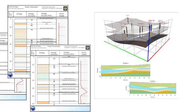
To equip students to successfully approach complex challenges in the real world, Mine guides them through various parts of the scientific process: gathering data, visualizing it, and analyzing it to see what the information reveals. To jumpstart this process, students collect electrical resistivity data, which they gather using 1D, 2D, and 3D survey schemes. With the 2D approach, Mine helps the students create a cross-section of the ground. Then, from there, she instructs students to use Surfer to bring their data to life.
“My students put together the electrical resistivity measurements they collected into an XYZ file,” Mine explained. “They grid that and create a contour map of that cross-section.”
The students’ maps reveal how electrical resistivity values change with depth and location, helping them locate key features such as a water table boundary and buried targets, the latter being particularly interesting. The field camp’s dedicated test site—originally designed by a former professor—includes buried objects that simulate real-world conditions. It’s the students’ job to find those objects using various data collection methods, including electrical resistivity. But electrical resistivity is just one tool in their toolbox.
Students also explore magnetic methods, which focus on detecting metallic objects underground. Why does this matter? Because metals like iron and nickel become weak magnets when exposed to the Earth’s magnetic field. If a sealed steel drum filled with hazardous chemicals was buried decades ago—and is now corroding and leaking—students must be able to track it down by measuring how it disrupts the Earth’s magnetic field. Fortunately, there are steel drums buried in WMU’s test site. Using magnetic readings and Surfer’s visualization capabilities, students map anomalies and locate these underground hazards with impressive precision.
“We live in the Earth’s huge magnetic field,” Mine explained. “So your keys in your pocket are weak magnets because they sit in that field. When something underground disturbs that field, our instruments can pick it up, and our students can find it.”
The final method students practice is electromagnetic surveying, which is especially useful for identifying conductive objects, including those same steel drums. Because they’re metal, they generate secondary electromagnetic fields when excited by a primary field. Students are responsible for measuring the distribution of these fields and using Surfer to visualize the data and pinpoint buried objects.
“Surfer plays a central role in helping my students interpret what’s beneath their feet,” Mine said. “The moment they grid their data and see that target light up, it all clicks. The software turns numbers into meaning.”
That moment where the map comes together and the hidden target is revealed isn’t just an educational milestone. It’s a moment that brings students genuine joy. As Mine explained, “The happiest they are is when I tell them we have a buried target, and they’ve found it. That’s the moment they’ve found the treasure.”
Equipping the Next Generation of Scientists One Module at a Time
At WMU’s Hydrogeology Field Camp, students not only learn about geophysics but also have the opportunity to experience it in a hands-on way. Thanks to Mine’s Surface Geophysics module, the next generation of scientists gets to collect data using innovative methods before visualizing it with user-friendly software like Surfer.
It’s this practical, hands-on experience that makes the module so powerful in its authenticity. By providing access to various methods and tools, students at WMU’s Hydrogeology Field Camp get everything they need to understand what’s happening beneath their feet so they can help tackle real, complex challenges in the future.
Want to read more stories like this one? Subscribe to our blog to discover some of the latest happenings in the world of geoscience!