How Geophysics Revived a School District’s Construction Plan: The Story of a Once ‘Un-Buildable’ Site
When a school district out west set out to build a new facility, they needed to know if their preferred location—which included a portion of a soccer field—was suitable for construction. After hiring a geotechnical firm to investigate the site, the school district got their answer: it wasn’t. Based on the results, the site was labeled “un-buildable.” But was it really?
Unconvinced by the vague conclusions and high uncertainty, the district sought a second opinion. That’s when they brought in a new geotechnical firm that consulted Andy Siemens, P.E., G.E., who is known for his innovative use of geophysics to deliver precise site evaluations.
Another Opinion and a New Approach
The school district’s initial investigation relied on air-percussion drilling methods, which included over 30 borings drilled across and around the soccer field. Although thorough in quantity, the results weren’t incredibly clear. The terrain—a complex volcanic landscape of fractured basalt and thin soils—produced inconsistent drilling responses that were interpreted as air-filled voids scattered unpredictably throughout the area, some estimated to be as large as 20 feet tall and just 10 feet below the surface. With limited confidence in their data, the original geotechnical firm recommended getting a second opinion, and the school district acted on their suggestion.
The new firm that they hired wanted to use sonic borings to better understand the extent of the voids, but this drilling method was expensive, leading to concerns about exploration costs. To keep the project within the school district’s budget, the geotechnical firm needed to limit drilling expenses by keeping their exploratory borings to strategic locations that were carefully selected. This is where Andy came into the picture.
The second geotechnical firm consulted Andy to discuss an idea: rather than blanket the field with costly sonic borings, Andy could perform a geophysical survey to map subsurface anomalies and guide the placement of future borings. This would reduce costs while increasing confidence. As it became clear that this approach was necessary, the geotechnical firm contracted Andy, who planned on conducting a survey using electrical resistivity tomography (ERT) in 3D.
But before jumping into the project, Andy knew stakeholder buy-in was essential—especially since geophysical methods are often misunderstood or overlooked. To build trust in the technology and approach, Andy first tested his methods on a nearby site known to have geologic features and air-filled voids similar to the ones that supposedly affected the school district’s preferred location. When Andy’s ERT survey results matched the known conditions, it gave stakeholders the confidence they needed to approve the survey at the school’s preferred site.
“We used software to show the results from that demonstration survey,” Andy said. “We created a 3D visualization of a known air-filled void to show that the method worked and provide confidence that if we apply the same method at the preferred site and there’s something we need to be concerned about, we’re going to find it.”
Revealing Geophysical Survey Results Using A Story-Driven Method
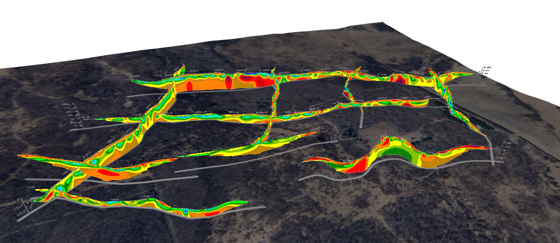
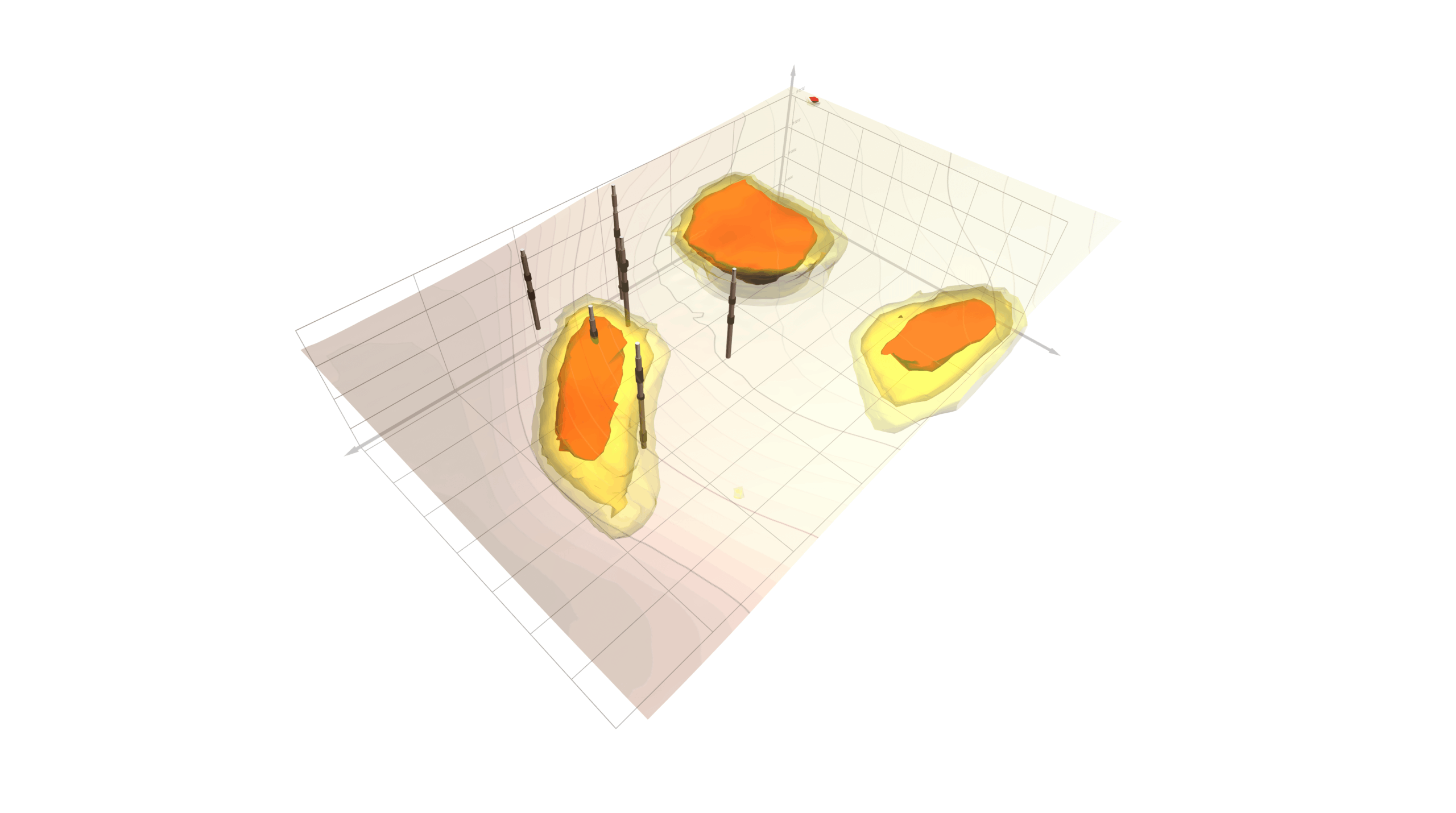
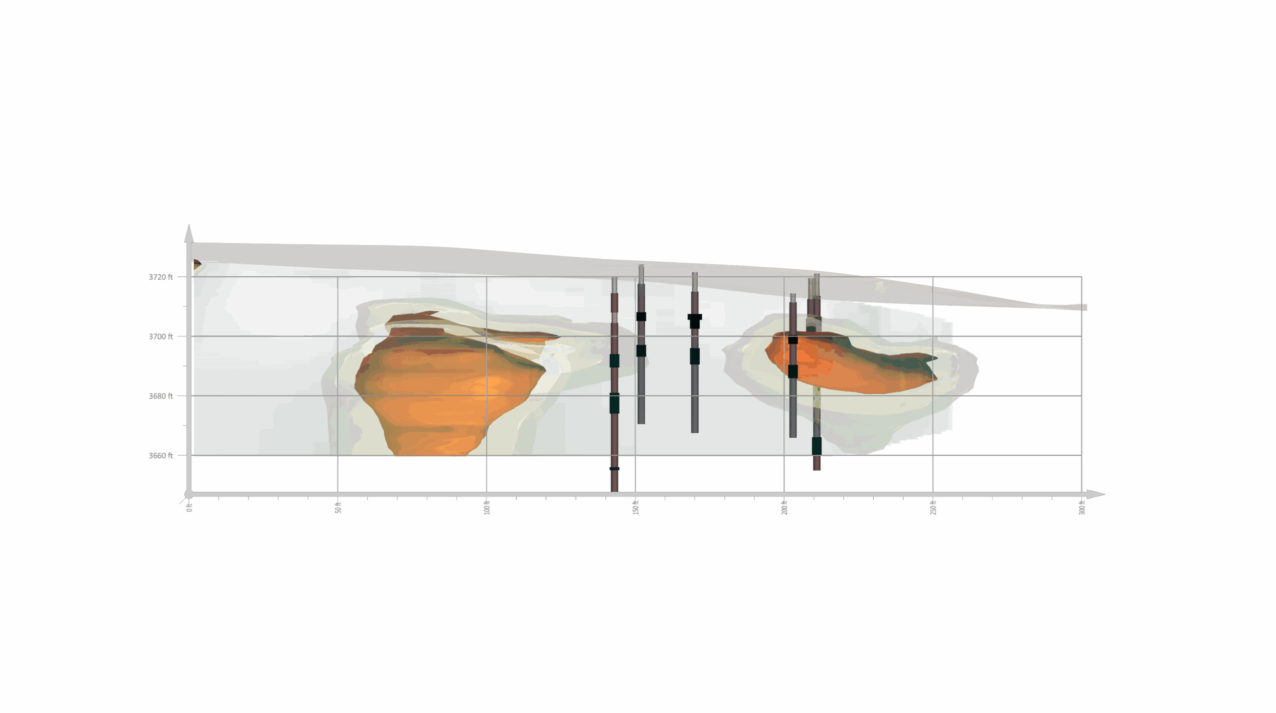
After moving forward with the ERT survey at the official project site, the results revealed a much more accurate picture of subsurface conditions. Andy identified zones of higher and lower resistivity—pinpointing areas where voids might be present, and more importantly, where they likely were not. Using the software, he then built a 3D model of the entire site that became a cornerstone of the project.
“One of the selling points was the 3D model,” Andy explained. “The stakeholders could look at that and get some confidence that, indeed, the entire site was explored. And if there were any issues or threats to the structure from subsurface conditions, they could be pretty confident that, if they existed, they would’ve been found.”
The 3D model included three critical elements:
- Contour layers to illustrate terrain slope
- Isosurfaces to showcase zones of anomalous resistivity
- Drillholes to highlight the precise locations for sonic drilling
These visual elements were critical, but for Andy, it wasn’t just about visualizing the data. It was about telling a story clearly and convincingly. The software played the biggest role in achieving this—but a video-making platform also helped.
For Andy’s report, he created a video that walked stakeholders through the model step by step. The video began with an empty 3D box, then progressively revealed the site topography, ERT results, and boreholes—all while Andy narrated what was being shown and why it mattered. As he explained the survey sequence, he revealed each corresponding point in the model, and this interactive, reveal-as-you-go approach helped bring his findings to life.
“You can describe everything in a video in a super cool way to deliver results,” Andy explained. “Clients love it. You’re able to tell a story and reveal it as it’s happening.”
The Truth Revealed: The Correct Status of the Preferred Site
The combination of geophysics and a story-driven 3D model helped guide the geotechnical firm’s exploratory borings, and their findings matched the results from Andy’s survey, one of which was a minor anomaly. This anomaly turned out to be a zone of unconsolidated pumicite surrounded by basalt—exactly the kind of subtle variation that could’ve been missed without targeted exploration.
“An anomaly had shown up in the 3D model,” Andy said. “Being able to visualize everything in the area of interest was really important. And the fact that the 3D model showed an anomaly within the zone of interest that the geotechnical exploration targeted was a big deal.”
The geotechnical company also confirmed that the subsurface was vesicular, fractured, and jointed, all of which were characteristics of highly variable rock. However, neither the firm’s sonic drilling method nor Andy’s geophysical survey found large, air-filled voids within the school district’s preferred location, which meant one important fact: the desired location wasn’t “un-buildable” but was actually usable.
Moving Forward with Confidence
Thanks to a combination of geophysical surveying, modern visualizing, compelling story-telling, and innovative drilling methods, Andy and his collaborators helped move a building project forward. The school district got the green light to develop a facility at their preferred location, and construction proceeded as planned. In the end, it was a win for the school district, the geotechnical firm, Andy, and the community that would benefit from the new facility.
Want to learn more about technologies empowering better decision-making and unlocking new possibilities in geoscience? Subscribe to the Golden Software blog for more stories like this one.
Recent Articles
- Jul 8, 2026|Gabbie Rhodes|14 min
Roger creates passage and tide tables that help mariners understand when and how they can move through the Thames Estuary’s swatchways.
- Jul 8, 2026|Gabbie Rhodes|10 min
Effective data communication is about making your maps and models easy to understand, and there are ways to achieve that goal. Discover the tips!
- Jul 1, 2026|Gabbie Rhodes|7 min
Geoscience projects are built on collaboration, but even the strongest teams can struggle with communication silos. Learn how to overcome them.
- Jul 1, 2026|Gabbie Rhodes|7 min
See how 3D visualization transforms geophysical data by connecting profiles with terrain, boreholes, and other datasets for better interpretation.