Illustrating Red Rocks Amphitheater Accessibility
Colorado summer is in full swing! Both locals and visitors to Colorado enjoy taking full advantage of the sunny days hiking, biking, fishing, tubing, paddleboarding, and participating in countless other outdoor activities. Many also take advantage of the cool summer evenings attending festivals and enjoying live music. One of the most popular venues for summer shows is the iconic Red Rocks Amphitheater, in Morrison, CO.
The Denver Post reported that Red Rocks Amphitheatre hosted a record 195 concerts and even more ticketed events in 2023, bringing 1.4 million visitors to this world-famous outdoor venue.(1)
A somewhat lesser known fact about Red Rocks is that it has miles of hiking trails with spectacular views of the foothills and metro Denver skyscape. The location of Red Rocks inside a sprawling mountain park leads both to beautiful scenery and accessibility challenges. Some of the most common questions among visitors are “Where is the best place to park?” and “Which is the best path to take into the venue?”
Mapping Red Rocks
Drew Dudley, our colleague and a regular concert goer, decided to try to answer these questions. He said “Within the park, there are six different locations where you can get dropped off or park your car. I thought it would be interesting to compare the distances from each of these parking lots to the center seating area of the amphitheater.”
This information should be a resource to help anyone who visits this beautiful landmark save their breath and take the shortest path in.
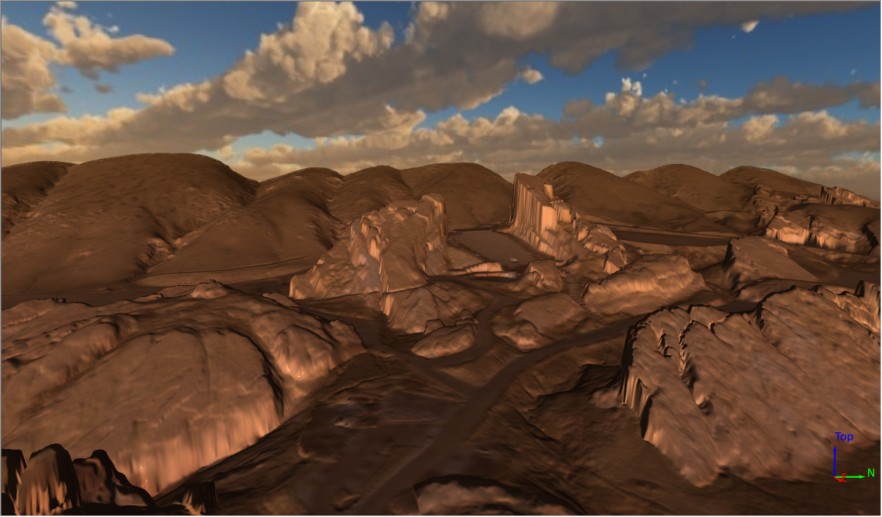
To create the map Drew first downloaded some public LiDAR data from the USGS and used that to create a grid and color relief map of the park. Next, a high resolution aerial image from Bing was overlaid on the map to provide visual context. Finally, profile lines from the center of each parking area to the theater center were added to illustrate the distance and elevation along each path.
Each profile and path were assigned the same color to visually link and identify them for the viewer. In addition, the profiles were all assigned the same horizontal and vertical scale so it’s easy to visually compare the distance and vertical incline of each trail into and out of the theater.

Surfer map illustrating the distance and elevation covered by each trail into Red Rocks
Knowing how far you’ll need to travel and how much vertical incline is required is especially important for visitors that aren’t used to the local elevation. As you can see from in the image above, if you park in the Lower South parking lot, you will have by far the furthest distance to travel and the most vertical incline to climb to get into the amphitheater. Compare this with parking in the Upper North parking lot, where you will have a much shorter and less strenuous travel time into the venue.
In the end, distance may be the greatest factor because an easy walk in could mean a strenuous walk out at the end of the night. Whatever your choice, we hope this information helps you have a safe and fun experience at Red Rocks!
References
(1) Red Rocks broke concert attendance records in 2023. John Wenzel. December 27, 2023. The Denver Post. https://www.denverpost.com/2023/12/27/red-rocks-2023-record-shows-statistics-attendees/
Recent Articles
- Jul 29, 2026|Gabbie Rhodes|12 min
Want to use AI for data visualization? First, consider this: while many AI-generated graphs initially look great, they can misrepresent your data.
- Jul 29, 2026|Gabbie Rhodes|9 min
Map elements often have the biggest impact on how confidently stakeholders interpret your data and make decisions. Discover which ones to use.
- Jul 22, 2026|Gabbie Rhodes|6 min
Your team needs to work together effectively. Discover strategies to enhance team collaboration, so projects move forward with greater confidence.
- Jul 22, 2026|Gabbie Rhodes|8 min
You need to produce clear, accurate maps, models, and graphs. Can AI tools for data visualization help? Here's the answer.