Drillhole Contacts and Surfaces are Providing Details About the Underground
It’s one thing to analyze subsurface data yourself. It’s another thing to translate what’s happening underground into a clear, compelling, and accurate visualization that others can easily understand and act on. One of the best ways to do it? Make sure your maps and models include the right level of detail.
The more precise and clear you can represent underground features, the more your stakeholders will grasp the situation and make informed decisions. Of course, providing this high level of detail requires having the right tools on hand—but fortunately, there are two upcoming features in Surfer that will help you get the job done well: drillhole contacts and surfaces.
Bringing Subsurface Details to the Forefront
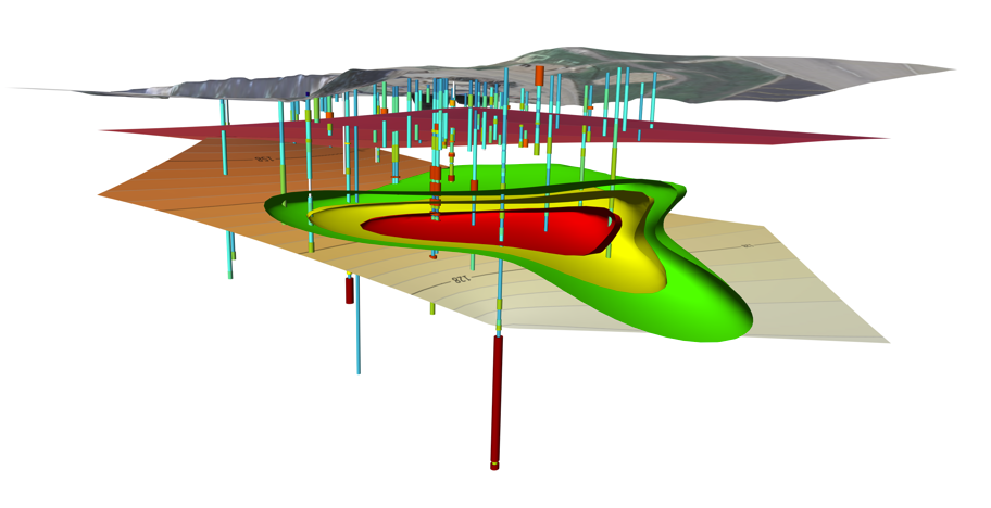
So what makes drillhole contacts and surfaces so special? The answer is simple. Visualizing 3D drillhole data is a solid first step to creating a clear, compelling, and accurate model in Surfer—but it’s just that: a first step. On its own, drillhole data doesn’t always tell the full story. They show where data was collected and what that data represents. If you also use drillhole keywords, you can see the geology within drillholes, but you can’t easily visualize what’s happening between your drillholes. And when it comes to making informed decisions, that in-between space is where key insights can live.
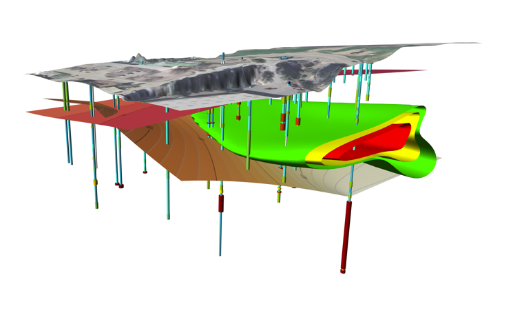
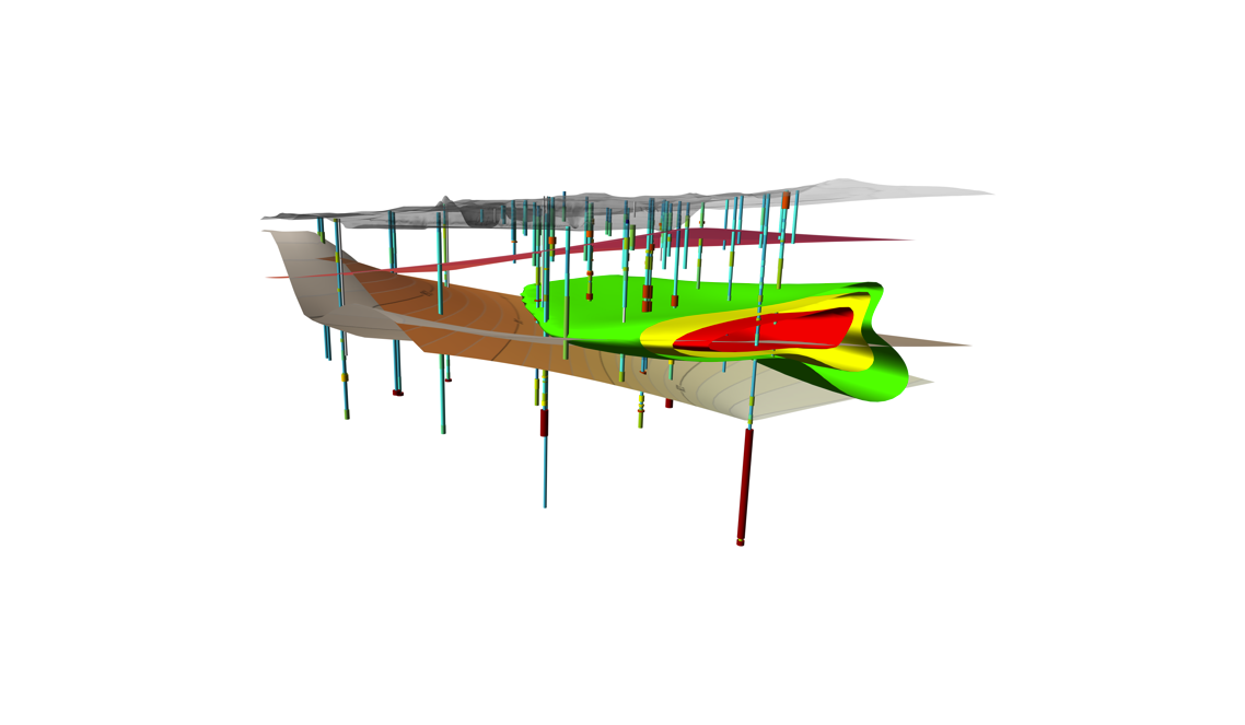
That’s why Surfer’s upcoming drillhole contacts and surfaces features are critical. These tools will let you go beyond the typical drillhole visual by equipping you to use text-based lithology data to define geological contacts and then connect those contacts across multiple drillholes to build surfaces. The result? A complete and informative geological picture.
Here’s a practical example to put this all in perspective. Imagine you’ve got ten drillholes spaced across your site. You know what each one tells you individually, but what’s happening underground in the gaps? Where is groundwater flowing? What geology exists in a certain area? Are more drillholes needed to help fill in or verify the geology in the gaps? With drillhole contacts and surfaces, you can answer these questions and visualize the continuity of geologic units across space, helping both you and your stakeholders understand the terrain in far greater detail to foster good decision-making.
And unlike some industry software that’s overloaded with complex tools and steep learning curves to achieve clarity, Surfer keeps it simple. The upcoming features are designed for the efficiency and functionality that’ll make your workflow faster, your visuals clearer, and your interpretations more actionable.
Real-World Applications: Who Benefits from Drillhole Contacts and Surfaces?
The ability to model what’s happening between drillholes isn’t just helpful—it’s mission-critical across many industries. Whether you’re planning infrastructure, managing natural resources, or exploring archaeological sites, drillhole contacts and surfaces can help turn isolated data points into a complete, actionable picture of the subsurface. In fact, here are just a few key sectors that will benefit the most from what’s in store for Surfer.
1. Infrastructure
Before engineers build any road, tunnel, or foundation, they need to know what they’re digging into. Is it sandstone—which is easier to excavate—or granite, which requires a different approach entirely? Understanding the geology between drillholes will help engineers plan more accurately, reducing costly surprises and ensuring safer, more efficient construction.
2. Mining
In mineral exploration, knowing where valuable materials are likely to occur is everything. Mineralization can follow specific rock units—so having the tools to map those units between drillholes is key. With contact picks and surfaces, geoscientists will have greater success constraining the size and direction of mineralized zones, leading to smarter targeting and better resource estimation.
3. Water Resources
For hydrogeologists, understanding subsurface flow is essential, especially when it comes to identifying porous zones that store or transport groundwater or pinpointing potential contamination paths. For example, if a high-permeability sandstone layer is sandwiched between dense, impermeable shale units, the water is going to stay in the sandstone. In that situation, a hydrogeologist may ask themselves: where’s that sandstone going? If they don’t have the answer, it’s a good sign they may need more information—and the drillhole contacts and surfaces will be able to inform their future drilling strategy to ensure they get the data they need.
4. Archaeology
While archaeologists may not work with geologic units in the traditional sense, they deal with time-based phases. Knowing what’s between excavation points can determine where to dig—or where to tread carefully. That said, drillhole contacts and surfaces can help archaeologists anticipate how deep artifacts might be buried and avoid damaging sensitive sites.
The Main Takeaway
In each of these fields, the message is the same: drillhole contacts and surfaces will help fill in the blanks. They’ll give context and clarity into data—so no matter your discipline, you and stakeholders will make better decisions about what’s happening beneath your feet.
Start Building a Clearer Subsurface Story
Surfer’s upcoming drillhole contacts and surfaces features will give you the opportunity to bring unseen areas to life, helping you communicate insights with greater detail, clarity, and confidence to foster informed decision-making. But as stated in this article, these features are upcoming; they haven’t been officially released in Surfer. However, you can start using drillhole contacts and surfaces in Surfer Beta. By participating in the beta program, you’ll be among the first to start modeling subsurface geology with drillhole contacts, and you’ll have a direct hand in shaping how it evolves when you provide feedback to help fine-tune functionality.
So don’t wait for the official launch to take advantage of what’s to come. Participate in Surfer Beta to explore the impact drillhole contacts and surfaces created from them can have on your visualizations right now.