Construction Planning in Europe’s Lowlands: The Critical Role of Floodplain and River Modeling
In Europe’s low-lying regions, water is a constant variable shaping daily life, infrastructure, and long-term construction planning. Nowhere is this more evident than in the Netherlands, where large portions of the country sit at or below sea level and depend on engineered defenses to keep communities safe. This geography has always required careful management, but today the challenge is intensifying.
In this environment, accurate river and floodplain modeling has become the foundation of safe, resilient construction planning. Whether designing new housing, upgrading infrastructure, or protecting critical assets, planners and engineers need realistic, data-driven insights into how rivers behave, where water will go, and how risks evolve over time.
Why Modeling Matters: Lessons From Europe’s Rivers and Recent History
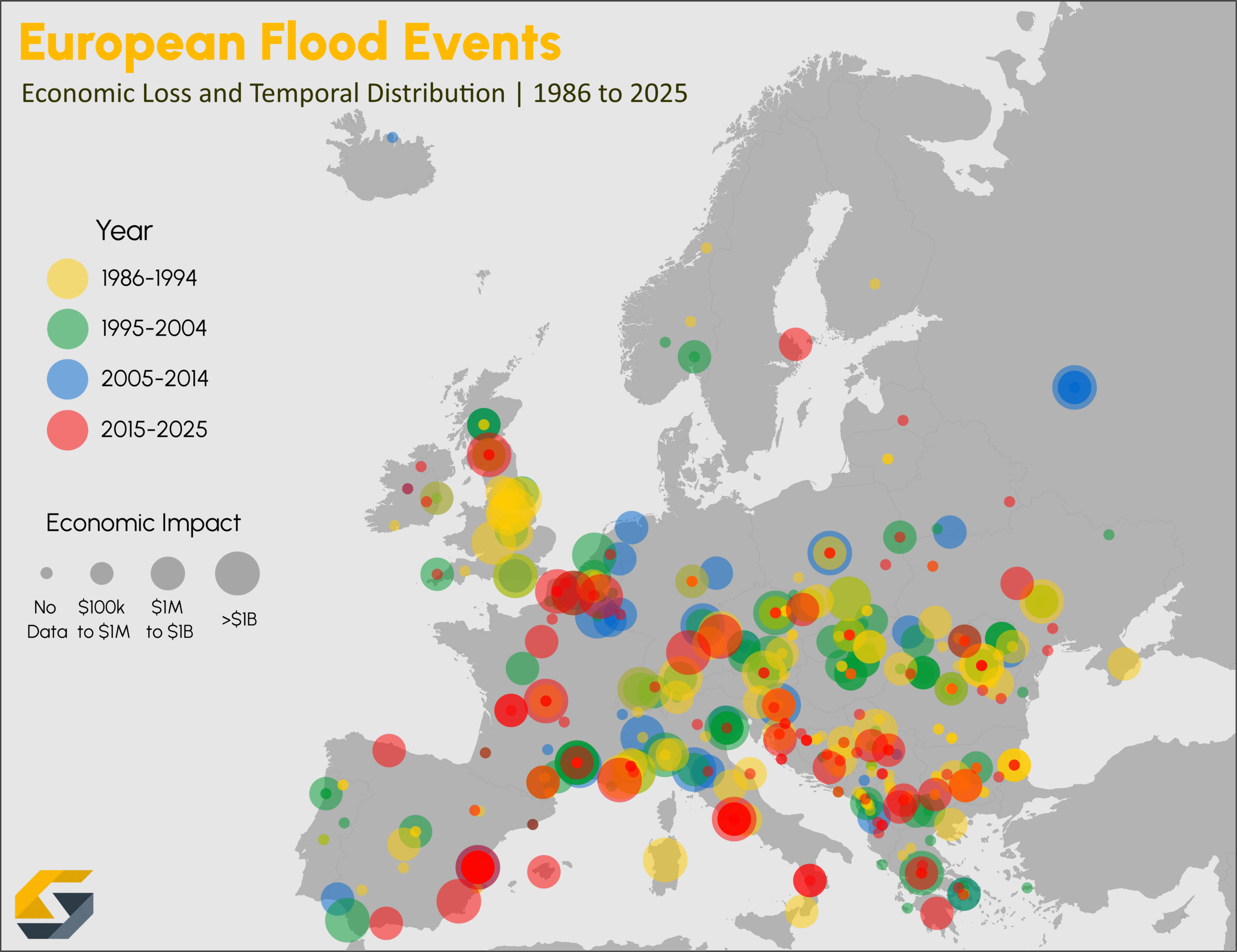
To understand why modeling is indispensable for modern construction planning, we only need to look at the rivers that define Europe’s lowlands. The Rhine River, the second-busiest waterway in the world, cuts through multiple countries before reaching the Netherlands, where its branches weave through cities, agricultural land, and critical infrastructure. Population growth and industrialization have altered this system, but the river is still a dynamic force. Small changes upstream—like shifting rainfall patterns in Germany—can ripple downstream in ways that dramatically affect water levels, flood stages, and flow paths.
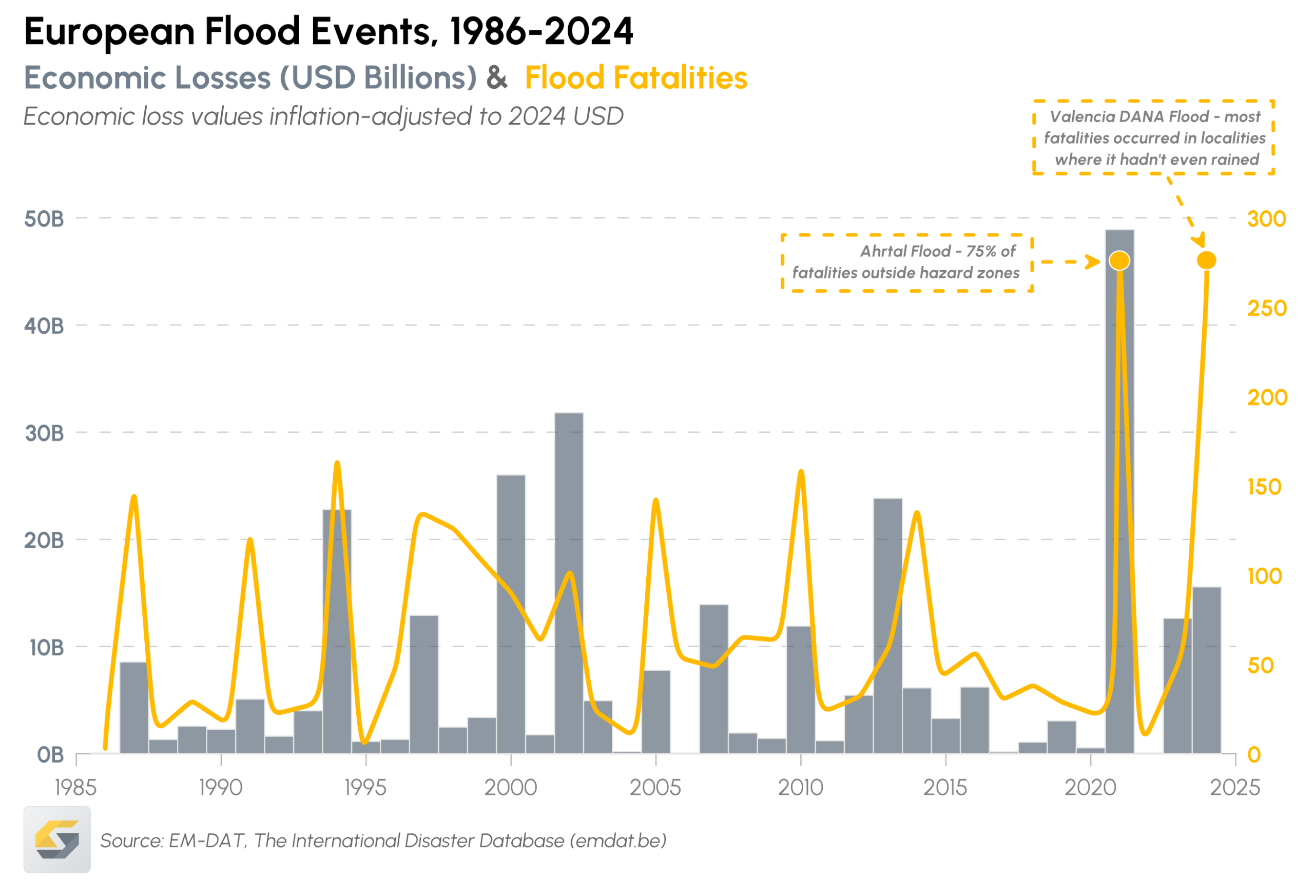
This became painfully clear during the 2021 Ahrtal summer flood in Germany. Fueled by extreme rainfall, water levels rose unpredictably and rapidly, overwhelming flood defenses and inundating towns with little warning. The European Geosciences Union (EGU) indicates that 190 people lost their lives. Additionally, homes and businesses were ruined by the force of water. One of the most sobering lessons from Ahrtal was how poorly understood high-water zones can turn into catastrophic blind spots. According to the EGU, 75 % of the flood fatalities occurred outside of the mapped hazard zones.
For low-lying regions like the Netherlands, this event is a roadmap for what must be avoided: river systems responding in ways that are unanticipated and leading to unpredictable damage. This is why accurate river and floodplain modeling has become essential to resilient construction planning. From siting new developments to designing protective measures, planners and engineers need models that reflect how rivers behave.
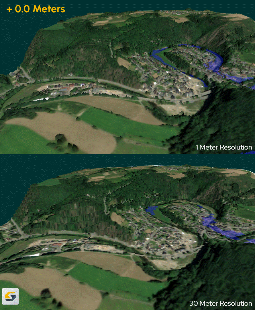
LIDAR Data Is the Foundation of Accurate Floodplain Modeling
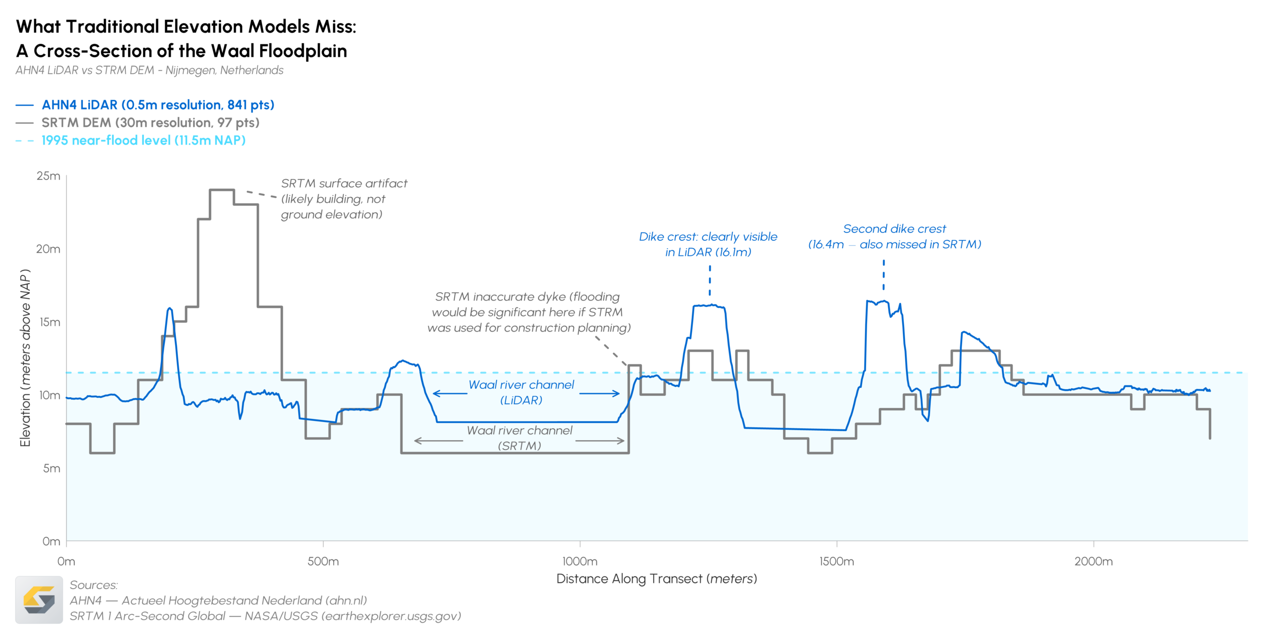
If past flood events have shown anything, it’s this: understanding how water moves begins with understanding the physical surface beneath it. Effective river and floodplain modeling always starts with a simple question: what landscape are we actually modeling? Answering that accurately is impossible without high-resolution elevation data.
Traditional elevation maps often smoothed over the very features that determine where floodwaters travel. But modern datasets—especially LiDAR-derived Digital Elevation Models (DEMs)—give engineers and planners the detail they need to understand risk at a much finer scale. Because LiDAR captures millions of measurements across a landscape, it produces a 3D representation of the terrain that includes levees, embankments, dikes, channels, infrastructure, and even subtle micro-topography that older methods would miss.
These fine-scale height differences matter enormously. A shift of just a few centimeters can determine whether water overtops a road, breaches a defended area, fills a retention basin, or diverts into a populated neighborhood. In low-lying regions—especially across the Dutch river delta, where gradients are shallow, and water seeks any available path—the impact of those subtle elevation variations is amplified.
Fortunately, when used in floodplain modeling, LiDAR-based DEMs help engineers identify:
- Where water will naturally accumulate or escape as it rises
- Weak points in levees or embankments where overtopping may occur
- Flow pathways and diversion zones under different rainfall or discharge scenarios
- Interactions between built infrastructure and natural terrain
For construction planning, this level of detail is essential. Whether designing a new housing development or upgrading dike systems, accurate elevation data ensures projects aren’t just compliant, but safe and resilient under future flood conditions.
Modeling River Behavior Is Essential for Safe Construction Planning
High-resolution elevation data provides insight into the physical surface. But to understand risk, planners and engineers must also understand how water will behave on that surface under extreme conditions. That’s where hydrological and hydraulic modeling becomes indispensable. These models simulate how rivers respond to rainfall, upstream discharge, storm surges, and infrastructure constraints, revealing patterns that simply aren’t visible from terrain data alone. However, hydrological and hydraulic modeling still have inherent differences.
Hydrological models help estimate how much water enters the system, while hydraulic models simulate how that water moves through channels, floodplains, and built environments. Together, they allow engineers to test a wide range of scenarios: normal river discharge, storm events, levee overtopping, ice-jam flooding, or rapid snowmelt. Within these simulations, three outputs matter deeply for construction planning.
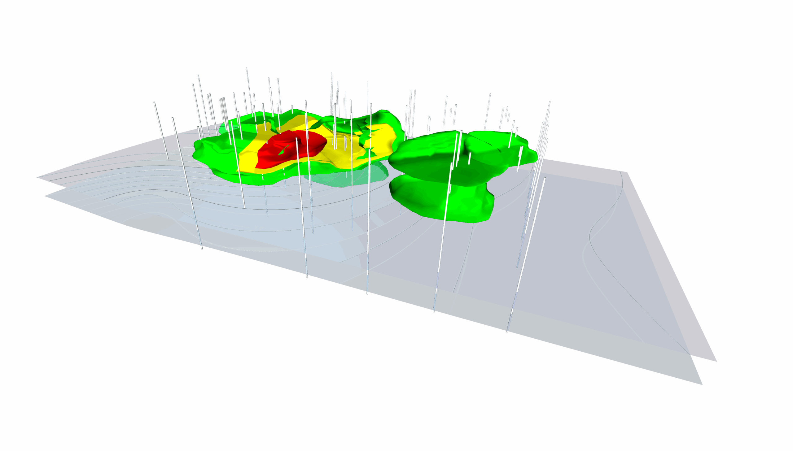
1. Flood extent: where will the water go?
Flood extent modeling identifies which areas will be inundated during events such as 100-year, 200-year, or 500-year floods. This is the critical first layer of risk assessment.
Flood extent visuals help planners:
- Identify high-risk zones that are unsuitable or restricted for new development
- Establish zoning boundaries, buffer zones, and construction setbacks
- Understand how changes to land use or infrastructure might alter future flooding patterns
Ultimately, flood extent answers the fundamental question: which areas will be underwater?
2. Water depth: how deep will the water be?
Water depth modeling shows how much water will cover the ground across different parts of the floodplain. This matters because 30 centimeters of water and three meters of water pose very different risks to homes, roads, embankments, and utilities.
Water depth estimates directly influence:
- Minimum floor elevations and design heights
- Foundation choices and flood-proofing strategies
- Infrastructure resilience (roads, utilities, pump stations, substations)
Overall, when it comes to water depth, it answers: how severe would the flooding be at this location?
3. Water velocity: how fast will the water move?
Even moderate water depth becomes dangerous when combined with high velocity. Fast-moving floodwaters can:
- Undermine foundations
- Erode riverbanks and engineered slopes
- Damage bridges, culverts, and retaining structures
- Transport debris that increases structural impact forces
Water velocity modeling is especially important near river bends, constrictions, levee transitions, and urbanized floodplains where flow paths accelerate. Velocity answers: How much force will the water exert and where?
Why Clear, Understandable Models Are Essential for Stakeholder Decision-Making
For all the insights they provide, floodplain and river modeling are only useful if the people who rely on them can actually understand what they show. After all, construction planning requires coordination among governments, developers, engineers, and property owners. That means flood risk information must be presented in a way that non-experts can quickly interpret and act on.
Clear, intuitive models turn highly technical outputs into insights that stakeholders can confidently use, which is especially vital in European lowlands like the Netherlands, where decisions can hinge on subtle terrain differences or complex water dynamics. To put that into perspective, here’s how visual clarity can accelerate understanding to anchor informed decision-making.
Government agencies: faster reviews, stronger compliance
Governments depend on accurate, easily interpretable models to issue permits, enforce development standards, and make policy decisions. Clear visuals help regulatory authorities:
- Understand whether proposed developments meet safety and zoning requirements
- Evaluate compliance with national and EU water management directives
- Identify where mitigation or adaptation measures are required
- Communicate decisions transparently during public consultations
When flood models are intuitive, governments spend less time deciphering technical details and more time evaluating the implications. This helps reduce delays during environmental review, improve trust between agencies and planners and engineers, and aligns construction decisions with regulations.
Developers and engineers: designing with confidence
Developers and design teams rely on clear modeling outputs to create infrastructure that withstands future conditions. When visuals clearly show flood pathways, depth variations, and high-velocity zones, engineers can more confidently:
- Select suitable building sites
- Determine foundation elevations
- Integrate flood-proofing or adaptation measures
- Avoid areas prone to erosion, structural stress, or impactful to surrounding communities
Clear maps lead to better design decisions and fewer costly redesigns. They also help developers justify construction choices to regulators, investors, and the public, reinforcing that projects are not only compliant but resilient.
Property owners: helping communities understand risks and prepare
For residents and property owners, flood models can easily feel abstract unless they’re visualized clearly. Understandable models help communities see the why behind construction decisions and protective measures, equipping them to take informed action.
Clear visualizations help property owners:
- Understand why certain areas require elevated structures or flood-proofing
- Recognize their personal risk and prepare accordingly
- See how future river behavior may affect their homes or land
- Trust that engineers and planners are basing decisions on robust, transparent science
When flood risk communication is visual, intuitive, and grounded in clear modeling, it empowers communities rather than overwhelming them. This is especially important in regions where water shapes everyday life, as it does throughout the Rhine–Meuse delta and other European lowlands.
Why Understanding Uncertainty Is Essential for Responsible Construction Planning
Even with clear visualizations, one truth remains: floodplain and river models are scenario-based tools—not absolute predictions. They reveal what is likely to happen under certain conditions, but no model can eliminate uncertainty entirely. For construction planning in Europe’s lowlands, acknowledging that uncertainty is not a weakness. It’s a critical part of building safely and sustainably. That said, here are a couple of things to keep in mind.
Where uncertainty comes from in construction planning
Every flood model reflects a series of inputs and assumptions. When any of these components shift, so do the results. Key sources of uncertainty include:
- Input data quality: DEM resolution, land-cover classifications, and drainage data all influence how water appears to move across the surface. Small errors can produce large differences in predicted flood behavior.
- Boundary and initial conditions: Assumptions about upstream inflow, soil saturation, levee performance, snowmelt rates, or storm intensity shape a model’s scenario. Real-world events rarely match these conditions perfectly.
- Climate assumptions: Relying solely on historical datasets risks underestimating future hazards. Climate-adjusted scenarios introduce additional uncertainty but also critical realism.
Because of these variables, two models of the same river may produce slightly different outcomes. This variability represents the space where engineering judgment must take over, where the data reaches its limit.
Why construction planning must incorporate uncertainty
Effective construction planning actively incorporates uncertainty. By designing with safety margins, conservative thresholds, and flexible strategies, planners and engineers can account for a bigger range of plausible outcomes—not just the “most likely” one. This could mean:
- Choosing sites completely outside—not just barely outside—high-risk zones
- Elevating structures above modeled flood depths rather than meeting minimum requirements.
- Designing foundations that account for erosion potential, not simply water depth
- Ensuring infrastructure can withstand both modeled and unmodeled extremes
In low-lying regions like the Netherlands, building in buffers is good engineering and planning.
Modeling Is the Backbone of Resilient Construction Planning
Ultimately, planners and engineers in Europe’s lowlands need clear, data-driven floodplain and river models that reveal how waterways behave and how they may behave under tomorrow’s extremes. LIDAR-derived DEMs, hydrological and hydraulic modeling, intuitive visualizations, and transparent communication of uncertainty all work together to give stakeholders the clarity they need to build safely and responsibly. When these tools are applied well, resilient construction planning becomes more achievable. Communities are protected, developments are designed with confidence, and decisions are grounded in scientific floodplain and river modeling.
As flood risk continues to evolve, so must the way we model, visualize, and communicate. If you want more insights on how to strengthen your workflows and make smarter, more resilient decisions, subscribe to the Golden Software blog and stay ahead of the next challenge.
Recent Articles
- Jun 10, 2026|Gabbie Rhodes|9 min
During peak season, it’s hard to complete high-quality work on time. Fortunately, some practical workplace productivity hacks can help.
- Jun 10, 2026|Gabbie Rhodes|5 min
When it comes to software, the right licensing model matters. A one-time fee and subscription are common options. Which is right for you?
- Jun 3, 2026|Gabbie Rhodes|9 min
What's the difference between these two 3D data visualizations: 3D View and 3D surface maps? Discover their top differentiators.
- Jun 3, 2026|Gabbie Rhodes|8 min
Hiring a skilled geoscientist or engineer is the first step to strengthening your team. The next is training new employees for success.