Choosing the Right Tool for Your Watershed Map: When Simplicity Beats Complexity

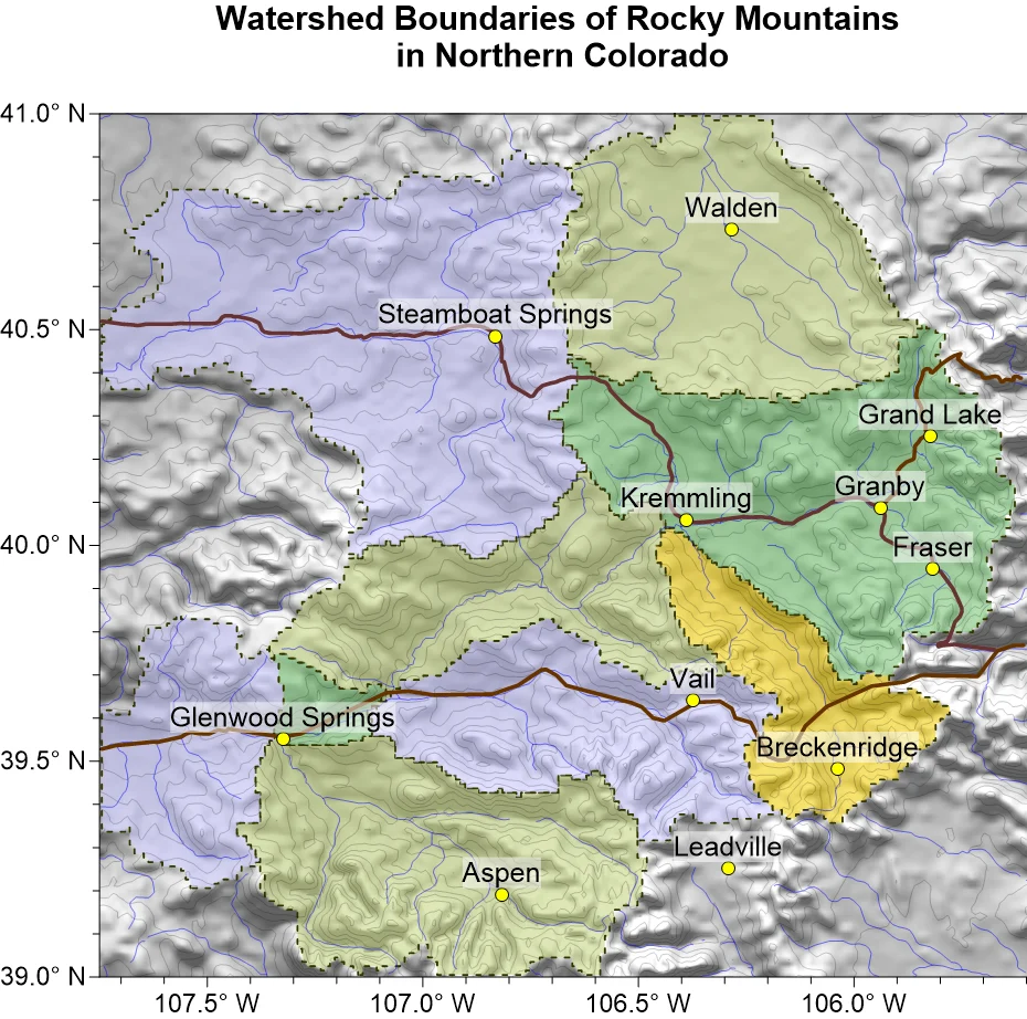
Creating a watershed map is one of the most common tasks in hydrology, environmental consulting, and land-use planning. Whether you’re evaluating stormwater runoff, delineating drainage basins, or assessing the environmental impact of a proposed development, watershed maps provide the foundation for countless technical decisions.
Yet two geo-professionals sitting side by side can approach a watershed map in completely different ways. One may spend significant time navigating a massive GIS software. The other may generate an equally actionable watershed map in under a minute using a straightforward, user-friendly program. Which one chose the right approach? The answer comes down to understanding how different tools handle the job.
The Traditional GIS Approach to Creating a Watershed Map
For some geo-professionals, watershed mapping begins inside a traditional GIS platform. This software supports a wide range of spatial analyses, making it a good potential option for organizations—but using it to create a watershed map typically involves a lot of work.
Before you can even generate a watershed boundary, you must first prepare the digital terrain so water can flow realistically across the landscape. From there, the software calculates how water moves over the surface, identifies where flow accumulates, determines where streams begin, and uses a designated outlet (sometimes called a pour point) to define the watershed boundary.
In a typical workflow, these steps look like the following:
- Loading and preparing a high-quality digital elevation model (DEM)
- Filling sinks or depressions to create continuous drainage paths
- Calculating flow direction and flow accumulation
- Defining a stream network using accumulation thresholds
- Selecting an appropriate pour point
- Delineating the final watershed boundary
Each step builds on the previous one, and many GIS workflows generate numerous intermediate raster layers along the way. It’s not uncommon to create 10 to 15 temporary datasets before arriving at the final watershed polygon. While these outputs are often valuable for additional hydrologic analyses, they also require additional processing time, consume storage, and can quickly clutter a project workspace.
There’s also a significant learning curve to consider. Because watershed mapping in GIS platforms relies on a sequence of specialized features, users who perform the workflow often find themselves revisiting documentation or double-checking individual steps before producing consistent results. The only big advantage that comes from the time investment is that traditional GIS programs typically produce vector watershed boundaries that integrate with other spatial datasets, making it easy to quickly calculate watershed area.
A Faster Alternative: Direct Watershed Mapping
Not every watershed mapping project requires a lengthy GIS workflow. If your goal is to quickly visualize drainage basins and begin evaluating a site, a dedicated mapping tool that’s user-friendly can dramatically simplify the process.
For example, a tool like Surfer empowers you to load a digital elevation model (DEM) and generate a watershed layer in a single step—often in about 30 seconds. The underlying hydrologic analysis still takes place, but tasks like sink filling, flow path calculations, and watershed delineation happen automatically behind the scenes. Rather than managing intermediate datasets, you can move directly from your terrain model to a finished watershed map.
That streamlined approach is especially valuable when speed matters. Whether you’re conducting a preliminary site assessment, preparing graphics for a client presentation, or evaluating drainage patterns during an initial environmental review, creating an actionable visualization quickly equips you to spend more time interpreting the landscape and less time building the workflow.
Still, with any approach, there are factors to consider. Traditional GIS platforms typically produce vector watershed polygons that make spatial calculations such as watershed area readily available. In Surfer, those same calculations simply require one additional step: exporting the watershed layer as a file and reimporting it as a base layer before working with the resulting polygon. For many projects, that’s a small consideration for a workflow that dramatically reduces complexity while still producing high-quality watershed maps.
Choosing the Right Approach for Your Watershed Map
To put the differences between a traditional GIS workflow and a streamlined mapping approach into perspective, it helps to compare them side by side. While both ultimately produce a watershed map, they differ significantly in the amount of time, effort, and complexity required to get there. The comparison table below highlights the key differences so you can see them more clearly.
| Factor | Streamlined Tool (e.g., Surfer) | Complex GIS (e.g., ArcGIS) |
|---|---|---|
| Primary Focus | Rapid visualization & intuitive presentation | Native polygon generation & spatial measurements |
| Steps to Watershed | 1 Direct Step | 7 Sequential Steps / Intermediate Layers |
| Time Investment | ~30 Seconds | 10 to 60+ Minutes (depending on user experience) |
| Output Type | Direct Watershed Map Layer | Polygon Layers + 15 Intermediate Rasters |
| Native Polygon Area | Requires brief export/import step | Calculated natively within attribute tables |
When Simplicity Wins
For many watershed mapping projects, speed and clarity are more valuable than an elaborate workflow. If your goal is to visualize drainage basins, evaluate a site, or communicate findings, a streamlined tool like Surfer lets you move from a DEM to a finished watershed map in seconds—without generating a collection of intermediate datasets along the way.
A streamlined workflow is particularly valuable when you’re:
- Conducting preliminary site assessments
- Creating maps for client reports or stakeholder presentations
- Working through multiple projects on tight deadlines
- Looking to reduce software complexity and keep your workspace organized
Instead of spending time building the workflow, you can spend more time interpreting and sharing the results.
When GIS Complexities are Worth the Cost
There are situations where a GIS platform could be valuable beyond watershed delineation itself. For example, traditional GIS workflows generate native watershed polygons that make calculations like watershed area immediately available. GIS platforms might also become valuable when watershed maps are just one component of a much larger enterprise GIS project. For projects focused primarily on watershed mapping, however, massive GIS software packages often come at the cost of a significantly more complex workflow.
The Right Tool at the Right Time
Creating a watershed map doesn’t have to involve a lengthy, multi-step process. As with many mapping tasks, the best software is the one that aligns with your project goals, timeline, and required deliverables. If you need a fast, accurate visualization to support site assessments, environmental reviews, or client communication, a streamlined tool can help you get there with far less complexity. If your workflow depends on immediately working with native watershed polygons or contributing to a larger GIS project, a traditional GIS platform could be worth all the additional steps.
The key is remembering that powerful software shouldn’t introduce unnecessary friction. By using streamlined tools for rapid watershed mapping and reserving more complex GIS workflows for projects that truly require them, you can work more efficiently, spend more time analyzing your results, and deliver high-quality outcomes faster.
What’s the latest project where you’ve had to create a watershed map? Share it in the comments below and tell us what the map was used for—whether it was assessing flood risk, supporting site planning, conducting an environmental assessment, or something else entirely.
Recent Articles
- Sep 23, 2026|Gabbie Rhodes|8 min
The best 3D data visualizations depend on the quality of your underlying grid. To achieve a great result, sometimes you need to use 3D grid filters.
- Sep 23, 2026|Gabbie Rhodes|11 min
When you're working with complex data, you need to communicate clearly. Graphs can help, especially when you follow design best practices.
- Sep 16, 2026|Gabbie Rhodes|7 min
The latest Surfer release delivers smarter 3D modeling, cleaner maps, and faster workflows. Unlock these benefits by discovering the top features.
- Sep 9, 2026|Gabbie Rhodes|4 min
Explore how Submara Survey bridged the gap between terrestrial elevation data and underwater bathymetry to guide costal development in Norway.